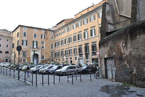
Yesterday evening (Friday, Jan 15) I decided to explore beyond my neighborhood of Trastevere (photo above) in a direction I hadn’t gone very far yet. I had purchased five single ride bus tickets (BIT) earlier at the tabacchi so decided to ride the tram line 8 out to the endpoint at Cosatello and go from there. Throughout my explorations I discovered some more neat pedestrian-friendly and happening streets outside of the central city antiquity, and also picked up a few things about the transit system.
The tram ride to Cosatello took about ten minutes or so. As visible on the map, once away from the heart of Trastevere near the river, the urban pattern becomes much more gridded and regular. The area is of course much newer than central Rome but besides a few main thoroughfares, the streets maintain a human scale and the buildings are mixed-use, in many cases more visibly active than many buildings in the older parts of the city. Typical apartment buildings there are five to six stories and stucco with muted colors. Facades are generally plane, but made lively by inhabitants. Autos are much more dominant on the streets, which are certainly more “friendly” to cars. The tram past a Ford dealership, though still extremely tiny by American standards and fully contained within a building. Car lots are non existent here. There were also some larger gas stations along the main roads as well. A lot of places, especially closer to the center of the city, tiny filling stations are located along the side of the roadway and cars simply pull over. I’ve noticed all of them seem to have attendants so perhaps self service is either not customary or legal.
Once I reached the tram endpoint I backtracked a few blocks until I came to Via Edoardo Jenner, a pleasant street characterized by apartment blocks with specialty shops at sidewalk level. I stopped at one complex of four apartment buildings that had a nice entry courtyard in the middle to sketch. As I continued further down the street it turned into a much more active retail district. After a number of blocks the concentration of retail terminated at a piazza so I turned the corner and went a few blocks to another major thoroughfare Viale dei Colli Portuensi.
This street was much wider than the one with the tram, with several lanes and generous setbacks. The scale of buildings were similar, but most were not attached to each other on the sides. In one sense it felt very suburban, but at the same time most ground floors of buildings were active by shops, restaurants, and commercial entities. Aside from the architecture, it somewhat reminded me of the wide avenues in some newer areas in the District of Columbia. In fact I notice a lot of parallels in different parts of Rome to certain attributes of various American cities I’ve visited.
View ROME 5 – Beyond Trastevere in a larger map
Navigating Bus Stops
I originally did not intend to venture to far away from the tram and until one point, even when I had gone quite far, was planning to simply turn around and return along the same route. But once I had been walking quite a distance I decided to simply follow the major thoroughfares I came upon and make a big loop back to tram. You can see my large loop on the map. My turn on to Via Portuense was by a narrow sidewalk along an off ramp. When I reached the next major intersection I began second guessing my direction. However after pondering a map at a bus stop sign for a moment and looking at the route information provided on the sign, I was able to use the bus stop signs to confirm I was heading in the right direction.
For each route serving a particular bus stop, the sign lists every street it goes on and how many stops on that particular street. I noticed the majority of routes at the stops I was passing had final destinations at Stazione Trastevere. At one point I walked too far past a street I needed to turn on, but realized about a block past when there were no more routes listed for Trastevere. Eventually I simply stopped at waited for one of the Trastevere buses – took route 774 – to get back to the tram. Of course once I got on the bus I discovered the tram was only about a block further away.
It was an enjoyable exploration outside of central Rome, but nonetheless a bit tiring. By using the bus stops to confirm my direction, I was able to better understand all the information on the sides and now the system seems much more legible to me. For someone with a broad knowledge of street names in Rome, it’d be quite easy navigating the system simply using the information provided at stops. Unfortunately the Roma ATAC website is not quite as thorough, particularly for buses, which is why it was less clear to me at first. Of course, knowing where you want to go is critical for getting around by transit, which was my main inhibition at first – simply not knowing anywhere to go outside of central Rome. I look forward to exploring more of the Rome metro via transit.
> Photos: (005) Beyond Trastevere
> Photos: (004) Friday urban history walk at Forum and Colosseum.


