Category: Cedar Rapids (page 5 of 9)

Why CR Transit Needs System Overhaul

I started a summer job last week, only a little late in the season, at the Facilities office at Kirkwood Community College in SW Cedar Rapids. Living on the opposite side of town, I elected to ride to bus to and from work, through a combination of choice and necessity. I never had my own car in high school and have, so far not found the need, desire, or financial surplus to purchase my own during the past four years of college. I have also become quite an advocate of public transit over the past few years, and admittedly a little bit anti-car.

Living on the northeast side of town, my commute requires transferring routes downtown at the long-term temporary transfer site, Lot 44, at 12th Ave and 2nd Street SE. Before last year’s flood that claimed eight transit buses and extensive damage to the city bus garage, route departure times were at consistent intervals, and service headways were pretty much the same for every route. Generally all routes had half hour service during the moring and late afternoons, with hourly service during the midday and Saturdays. The only anomaly was the Route5’s (5N, 5S, 5B) which all run along 1st Avenue to Lindale Mall, then diverging along three different routes – serving north Marion, south Marion, and Hiawatha respectively. A 5 bus would depart downtown ever 30 minutes, but each individual route (5N, 5S, or 5B) would actually only leave every hour and a half.

When transit service resumed after the flood, there was limited service – I believe all routes started with hourly service during the day – I imagine due to a combination of lost busses, new flood-related expense circumstances, as well as assumed temporary decreased demand. Since then some routes have increased service to 30 minute headways in the morning and afternoon, but not all routes, including Route 3, the one that I can conveniently catch right behind my house in NE Cedar Rapids and ride downtown in about fifteen minutes.

The way the bus routes are laid out in a “spoke and wheel” fashion, makes it generally easy and convenient to commute to and from downtown if you’re near a route, but mobility between different areas of town – especially if they are on the same side (east or west) of the river/downtown – is much more difficult. Every single route originates in downtown and extends outward, like spokes in a wheel. Some routes occasionally cross each other but there is no systematic coordination for transfers between any routes outside of downtown. It is probably possible in some cases (I haven’t studied the schedules close enough), but it would be up to the passenger to investigate ahead of time on their own.

In my case, I’m traveling from the NE side of town to the SW, so transferring routes in downtown is convenient and efficient. But I still have problems with differing service frequency among routes and the fact that it takes me 50 minutes to ride to work. My “home” bus stop is along Route 3 at Lindale Ave and Tiffany Drive NE. Route 3 continues to operate “hourly” (70 minutes in the afternoon) all day, since service reductions after the flood. To get to Kirkwood I take Route 7 from downtown. 7 has resumed half-hour “peak” service in the morning and afternoon. My general working hours are pretty standard, 8am – 5pm with an hour break for lunch. The times hourly Route 3 meets up with half-hourly Route 7 to transfer do not work very well with my given schedule.

Route 3
At Lindale Ave
Route 3
Arrive Lot 44
Route 7
Depart Lot 44
Route 7
Arrive Kwood
6:25am 6:40am 6:50am 7:15a
– – – – – – 7:20am 7:45a
7:25am 7:40am 7:50am 8:15a
– – – – – – 8:20am 8:45a
8:25am 8:40am 8:50am 9:15am
Route 7
Depart Kwood
Route 7
Arrive Lot 44
Route 3
Depart Lot 44
Route 3
At Lindale Ave
4:15pm 4:40pm – – – – – –
4:50pm 5:18pm 5:30pm 5:45pm
5:15pm 5:40pm – – – – – –
6:00pm 6:28pm 6:40pm 6:53pm

As you can see I am pretty limited to certain times I can go to work and what times I can leave. Fortunately my workplace is pretty flexible so I just come in early at 7:15 (taking the 6:25 number 3 bus), but I still must stay there longer than an eight hour day in order to take the 4:50 Route 7 bus in the afternoon that will connect me to Route 3 in a timely fashion. Additionally, taking 50 minutes to travel a mere 10 miles or so is also not very convenient for me. In the current route structure, many routes loop around and a number of different streets in effort to cover the most physical area in a single route. This makes getting to your actual destination very time consuming and extremely inefficient. Bus routes that serve major destinations such as Kirkwood or large employers like Aegon and Rockwell Collins need to have more direct routes.

I’ve come up with four main criteria to evaluate the CR transit system:

   1. Can I get to my destination on the bus routes?
   2. Can I do so at a time that works with my schedule?
   3. Can I travel by bus in a timely manner?
   4. Is the bus comfortable and attractive?

In my case, the answer to criteria one would be yes. I can catch the bus right behind my house and get off the bus right by the building I work in at Kirkwood. For criteria two, the answer would be “sort of” – it is possible to get to and from work reasonably within my required timeframe, but there is certainly no flexibility. Three, can I travel in a timely manner? Absolutely not. A more direct route from downtown, or wherever routes connect, to Kirkwood could decrease my travel time. And, finally criteria four – the current bus fleet of majority older buses does not make for the most pleasant ride, but even more so, gives the system a less than stellar public image.

Fortunately all these issues may start to improve. The fourth issue should be the most visible improvement to come. Four brand new buses have arrived this month and should go into service within a few weeks. Additional new buses will be purchased over the next few years to replace older vehicles.

Regarding the first three issues, the Corridor Metro Planning Organization has issued a request for proposal to consultants for a fixed-route system analysis and recommendations for system improvements including changes to routes and schedule. According to the RFP, “The proposed routing options should focus on reducing travel times, increase the service area and increase the transit ridership. The analysis should include specific routing options, service schedules, expected ridership and driver scheduling.” A consultant is to be selected by July 17, and work is expected to be completed by mid November. The study, partially prompted by criticism of the system during the Neighborhood Planning Process earlier this year, will include three public open houses.

There are obviously many improvements – large and small – that could make CR Transit a much more effective system. In a future post I plan to further explore improvements and specific changes I believe will be necessary to bring Cedar Rapids’ transit system up to par. It is critical that Cedar Rapids becomes a more transit-friendly city.
Parking replaces 100-year old houses on First Ave

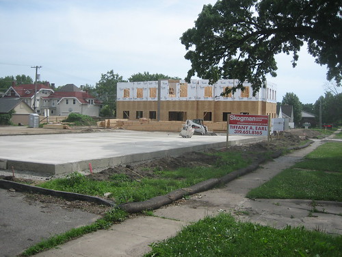
A new 10,000 square foot, two-story professional office building is currently under construction at 1815 First Avenue SE in Cedar Rapids. The development is replacing four former residential properties at 1815, 1821, 1827, and 1833 First Ave SE, all built between 1900 and 1921. According to the Cedar Rapids Assessor’s records, these houses had all been converted into multi-tenant. None of these houses were in the best condition and understandably this area of First Avenue is very marketable for commercial use, so I’m not going to argue against the destruction of these century old homes, but the new use of the site is unfortunate.

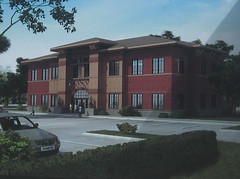
Rendering of development at 1815 First Ave SE

Above is a rendering of the finished building. It is fairly suburban looking, but two-stories is nice and the scale is appropriate. The building is set back from the sidewalk about the same distance as existing older houses and commercial buildings nearby. My only real problem with this development is how much of the site fronting the sidewalk has been used for parking. The site is approximately 250 feet long (along First Avenue) and maybe 150 feet deep. The building was constructed on one end of the site with the rest left open for a parking lot.

If this type of new commercial development cannot survive without minimizing it’s parking requirement, or situating it more appropriately on the site, then perhaps this use does not belong here. I welcome reinvestment in this older part of the city – and especially diversification of uses, but it must be done respectfully and not diminish the urban quality that remains. 150 feet of parking lot along the sidewalk and the street is not progress, it is a gouge out of the former street edge that made this block pleasant to walk or drive down.

Below are the four houses that were torn down for this development, not to mention tree fatalities. The images are arranged in the same order of the former houses. How long will this kind of auto-centric redevelopment go unquestioned?

1833 1st Ave SE1827 1st Ave SE1821 1st Ave SE1815 1st Ave SE

1833 – built 1910, two story frame, three family conversion / 60 ft wide lot
1827 – built 1910, two story frame, four family conversion / 60 ft wide lot
1821 – built 1900, 1-1/2 story frame, three family conversion / 60 ft wide lot
1815 – built 1921, one story frame, two-family conversion / 60 ft wide lot

Finally, Brand New Buses in Cedar Rapids

The four brand new 35 foot, 2009 Gillig Lowfloor buses for CR Transit have arrived. They are not out in service just yet, but I was able to get a few preliminary photos of the new buses from fellow transit enthusiast James Roach. In these photos, a few details remain to be added (like the CR Transit lettering, 5 season tree logo, etc). Also the front of the bus below the windshield is green like the sides, it’s just still covered up with wrapping in the photos.

The exterior color scheme follows a new “CR Transit” branding that’s already in place on the eight used TMC RTS buses purchased earlier this year for flood replacement. The system officially dropped it’s former “EAGL” moniker and became known as CR Transit / Cedar Rapids Transit over a year ago. The existing older buses – old RTS’s and the Thomas Dennis SLF lowfloors – were not repainted but “EAGL” has been removed and replaced with the stylized “CR Transit” lettering.

This arrival is a pretty big deal, being the first brand new buses Cedar Rapids has seen in 10-15 years. Bill Hoekstra, head of the former combined transit and parking department, was an advocate of purchasing refurbished used buses instead of buying new. This saved the city some money but has done little for the bus system’s image. CR Transit will be purchasing additional Gilligs over the next few years to finally modernize the fleet. The new buses, units 2091-2094 (2 is the city dept. code, and 09 refers to year of manufacture). They should be in service within the next couple of weeks.

Check back frequently for new photo updates and other CR Transit news.

TCR could return downtown by next spring

With the help of a $1.5 million grant from Vision Iowa, Theatre Cedar Rapids and the Community Theatre Building Corp. hope to begin a $7.8 million expansion and renovation of the Iowa Theatre Building in downtown Cedar Rapids by the end of summer or early fall. FEMA is expected to contribute about $3.8 million for the flood-damaged building. According to the Gazette, “Outside the theater, visitors will see a new digital marquee. Inside, they will see a lobby that doubled in size. Larger restrooms, an open staff office and rehearsal space also are part of the project. The theater’s basement will house new dressing rooms, a make-up room, costume construction plus storage and rehearsal space.” Since the flood last June, TCR has been performing at the former “Let’s Dance” building by Lindale Mall.

Parlor City opens in New Bohemia

I had dinner tonight at Parlor City, a new pub and grill that has opened in a renovated 100 year-old building (see photo) that was flood damaged last summer in New Bohemia. The food was decent and the atmosphere was friendly. The menu features an historic image of the building, formerly the Iowa State Savings Bank, that can also be seen on their website. The restaurant’s name is appropriately a former nick-name of the city. Long before the fifth season came around, Cedar Rapids used to be called the Parlor City for its beauty and cleanliness. At the corner of 12th Ave and 3rd Street SE, this is a great addition to the neighborhood and a good example of a flooded building coming back better than before.

> Parlor City Pub and Eatery

Figure Ground Development Patterns

Figure-ground diagramming is an interesting and useful tool for analyzing spatial relationships in urban environments. It also provides a striking comparison of density and land use of older urban development compared to more contemporary suburban development. In older, urban places buildings typically took up the majority of space on a city block so even when diagramming built structure as figure (black) and space without structure (ground) the graphic would essentially depict the street grid. In more contemporary development however, auto-centricism has made for much more spread out buildings divorced from the street edge. Instead of relating to the street and sidewalk (if there even is one), these buildings related to their respective parking lots. Figure-ground diagrams of these sorts of places are often difficult to discern where roads actually go, but are very telling at the amount of open space wasted on the temporary storage of cars.

The figure-ground diagram above is an example of one of these suburban places that lack order and urban spatiality. They vast openness surrounding the buildings makes it hard to tell where roads go or even scale. The variety of building orientation in this case makes it even more difficult to decipher. In the image below, the roads are included, and we can begin to understand more about this space.

The diagram shown is of the Lindale Mall area in northeast Cedar Rapids, where First Avenue and Collins Road intersect. First Avenue is the road running diagonally from the lower left-hand corner up to the top right. I first decided to explore this area through figure-ground after noticing the actual corner of First Ave and Collins is very undefined. In fact, hardly any of the buildings in the study area relate in orientation or proximity to the street at all.

In the image below I stitched together multiple bird’s eye views from Bing Maps. The predominance of pavement stands in stark contrast with the lush green, tree-laden land to the south. The awkward angles at which big box stores were built, situated far from the street, combined with sloping terrain, makes for a very haphazard, almost disorienting, landscape. Driving along First Avenue, the only thing definite is that you are constantly surrounded by parking lot. Asphalt abuts the street the entire length, with only a few small outparcel structures even nominally close.

The area began developing in the 1960s, following the construction of Lindale Plaza, later enclosed as the indoor mall it is today. Besides Lindale, most of the larger scale retail developments there today were only built in the last ten years or so, as older properties were redeveloped. These recent redevelopment areas comprise a significant amount of the First Avenue corridor, and every single one disregards site context and has little relationship to the street. How unfortunate since these will ultimately remain for at least the next few decades.

So why is this a problem? The chaotic development pattern makes finding particular businesses – especially while driving – more difficult, and is very inconvenient for pedestrians. Even if the area had a complete sidewalk network, going from place to place would take much longer on foot than if buildings were closer to the road. I also don’t think massive parking lots make for a very attractive street environment.

Now I’m not advocating no parking, but what if the placements of all these buildings were simply switched with their respective parking areas? If buildings were located by the street and parking placed in the rear, it would be more accessible and equitable to those arriving on foot, bike, or bus – while still serving car customers just as well. With buildings all along the street, it would reduce the distance between places, making it easier for people to get to multiple stores and restaurants in the area on foot. In the current setup, it’s likely most people will get back in their cars just to drive over to the next store rather than walking.

Aesthetically, the street would be much more attractive with a well defined edge. This would provide the area a stronger sense of place and urbanity, instead of the anonymous suburban scape that exists now. Distance-wise, the mall and surrounding development is really quite close to a large residential area, just a few blocks down First Avenue, but right now there’s not even a sidewalk from around 40th Street up until the mall, where then, there is only a partial sidewalk along the south side in front of Home Depot. Even so, if a continuous sidewalk existed, psychologically the perceived distance from nearby homes would be quite long due to the spread out configuration of buildings. Built-up density makes walking distances seem shorter, while vast open space – like parking lots – makes distances seem longer.

If newer buildings like Home Depot and Marketplace on First had been built up to the street, this area would already look and feel more dense and closer together. With a more urban scale, nearby residents may find walking or catching the bus (pending improved transit service) to be more convenient than driving the five or six blocks to the mall. Unfortunately the current setup encourages and almost necessitates driving.

I don’t expect this area to ever drastically change, especially since many of these developments are relatively new, but I do hope that other new large and small scale commercial developments will be more respectful of the street and accommodate customers arriving by all different modes equally. Urban design is not only about how the environment looks, but about how it is organized, oriented, scaled and proportioned. Good urban design can have a profound impact on the accessibility, usability, and sustainability of new developments.

CR Open House, meetings this week

The City of Cedar Rapids held the first of three public open houses today at the Crowne Plaza, presenting information on future of city facilities and parks and recreation resources. I attended today’s open house and submitted my feedback. Comment cards with specific questions were provided to help guide the decision making on flooded city buildings. Three options have been presented: 1. to return to flood-affected buildings restored to their pre-flood conditions, 2. to return to flood-affected buildings with improvements and/or expansion, or 3. relocate functions to a new facility or facilities possibly shared with the county or school district.

I believe a combination of options two and three are most appropriate. Since the county has already decided to return to it’s pre-flood administration building, it doesn’t seem to make sense to still attempt a co-location for administration. I believe it’d be best to return City Hall to Veterans Memorial Building, which I have argued previously. However, some city buildings obviously need to be replaced and would actually serve the community better in a new facility.

For those unable to attend the open house today, the city will be setting up a website so citizens can submit feedback online. The next open house will be August 18, and the preferred options will be presented at the final open house on October 6.

Also, the City of Marion held a public meeting today for citizen input regarding a new comprehensive development plan underway.

Additionally the Corridor Metropolitan Planning Organization will hold an open house this week to present their funding decision for metro area transportation projects in 2013. This will be held Friday, June 26, at the Hiawatha Community Center from 5:30 – 7pm.

Also… see update to “Planning for Better Transit” post below regarding CR Transit system analysis.

> Corridor Recovery: Cedar Rapids Open House

Planning for Better Transit

KCRG ran a story yesterday about possible route and service changes coming to Cedar Rapids Transit to make the system more convenient and efficient for citizens to use. Prompted by feedback from the Neighborhood Planning Process, the Corridor Metropolitan Planning Organization intends to study alternative route structures this summer, such as using Lindale and Westdale malls as hubs. The current “spoke and wheel” system, in which all routes originate from downtown, only works well if you are heading to or away from downtown. Another issue is frequency of service and limited hours of operation.

> KCRG: CR Bus System Could Get Overhaul

* UPDATE (6/23) *
The Corridor MPO has put out an RFP for a fixed route analysis of the Cedar Rapids Transit system. A consulting firm is to be selected by July 17, with the study completed by November of this year. The selected firm is expected to hold three open houses for the public and interested parties to provide input.

> Corridor MPO: RFP – CR Transit Fixed-Route System Study

Neighborhood Reinvestment Action Plans published

The Cedar Rapids Neighborhood Reinvestment Action Plans have been published on the Corridor Recovery website. This plan was developed by Sasaki Associates with a great deal of community input through the Neighborhood Planning Process during the first few months of 2009. It was approved by the City Council on May 13, to guide short and long term redevelopment in flood-affected neighborhoods. The final action plan includes a specific set of tasks to be completed that will compliment comprehensive goals.

> Neighborhood Reinvestment Action Plans

New public library branch opens downtown

A new temporary downtown library branch opened in the Armstrong Centre today, one year after flood waters filled the former main downtown branch. Since then, the Cedar Rapids Public Library has operated out of its branch at Westdale Mall, and recently expanded into a larger space there in the former Osco Drug store. The downtown location will be open weekdays from 10am – 6pm, and during the Saturday morning downtown farmers market throughout the summer.

The library board has voted to put a property tax levy increase on the ballot in November, to increase the current library of 4 cents per $1000, to 27 cents. This would end up being a $23 annual property increase on a home valued at $100,000 – a small price to pay for the future of our public library. From the Gazette, “[FEMA] funding will help pay to restore what the library lost in the flood and to build a new library, but a new tax increase would go for library operating costs, particularly when a new library is completed in 2011.”

In March, FEMA declared the flooded downtown library hit the 50 percent damage threshold, meaning it would help fund total replacement of the current building instead of repairing it. A new library is expected to be built on a different site in downtown, further from the river. An exact location or timeline has not been determined.

Older posts Newer posts

© 2022 URBAN THINKING

Theme by Anders NorenUp ↑